Showing posts with label Connecticut. Show all posts

16 March 2020

State schools closed in response to COVID-19 pandemic

In response to the novel coronavirus (COVID-19) pandemic, Vermont Governor Phil Scott has directed that all state schools close no later than Wednesday, March 18. The schools will remain closed at least through April 6, according to a press release.

Update, March 26, 2020: The governor has directed schools in the state to remain closed for the rest of the 2019-2020 school year, according to a press release.

Scott called for local school districts to plan for the food and special needs services of children, for childcare requirements of healthcare workers and others essential to the state response to the crisis and for the continuation of student education during the dismissal period. This last priority is to include the assignment of trackable work for students to do at home and the creation of a remote learning plan in case the closure must continue past April 6.

The governor's March 15 announcement stated that no students in the state would be required to be in school on Monday or Tuesday, March 16-17, if their parents or guardians would prefer to keep them at home.

"The orderly dismissal of schools is essential to support both the state's response to COVID-19 and the needs of children and families in Vermont," the governor said. "We must ensure children are safe, nourished and still learning even as the traditional structure of the school is disrupted."

Rutland Northeast Supervisory Union, which oversees the schools of the Otter Valley Unified Union in Whiting, Sudbury, Leicester, Brandon, Pittsford and Goshen, responded to the governor's directive by notifying district parents in a March 15 letter signed by Superintendent Jeanne Collins.

The school district stated that its buildings would be closed to students after Tuesday, March 17. Teachers and paras have been assigned to spend the remainder of the week preparing assignments for students to complete at home.

The district is planning to deliver meals to any student/household requesting the service. It intends to deliver bagged breakfast/lunch to homes using buses. The buses may also be tasked with delivery of school lesson materials.

The Addison Central School District, including Middlebury schools, released a March 15 letter confirming that students would be dismissed at the end of the day Tuesday, March 17. The district pledged additional communication with parents on matters relating to continuing educational services and providing food and learning support.

COVID-19 in Vermont

The State of Vermont has a dozen COVID-19 cases, according to a March 16 report by the Seven Days newspaper. Three of the most recent four cases do not appear to be related to travel by the affected individuals. That indicates that "community transmission" from one person to another is occurring within the state.

The U.S. Centers for DIsease Control and Prevention (CDC) reports that COVID-19 is a global pandemic. At last count, more than 6,500 people around the world have died from the virus. As of midday, March 16, there were at least 3,910 cases within the United States. Though the U.S. is still in the early stages of an outbreak, seventy Americans already have died. West Virginia is the only state without a reported case. (West Virginia's coloring in the CDC map below appears to be an error.)


According to a press release by Vermont Commissioner of Health Mark Levine, M.D., symptoms of a COVID-19 infection include fever, cough, fatigue and shortness of breath. Most people affected by the virus - classified as the SARS-CoV-2 virus - will have mild symptoms. About 15 to 20 percent of patients will experience severe illness. Older people and those with existing health problems, including lung disease, heart disease and diabetes, are particularly at risk.

Not a roll in sight.
(Middlebury Hannaford)
 Dr. Levine urged those who experience mild symptoms to remain home and contact their healthcare provider for guidance. Patients with more severe symptoms and patients who have mild symptoms but also belong to high-risk groups should contact a physician as quickly as possible.

The possible transmission of the virus from one person (who may or may not have symptoms) to another person has caused the cancellation of numerous gatherings and popular sporting events, as well as the closures of colleges (see Middlebury College article), schools, museums and other establishments. On Monday, March 16, Governor Scott issued an executive order banning large nonessential gatherings. Gatherings are limited to no more than fifty people or fifty percent of an establishment's occupancy, whichever is less. The states of New York, Connecticut and New Jersey also have banned groups of more than fifty people. Rhode Island has banned groups of more than twenty-five.

Around the country, retail stores are experiencing panic buying and hoarding of various food items and supplies. Stores in the Whiting area have bare shelves where hand sanitizer, cleaning products and toilet paper were formerly found. Certain food items, including pasta and some frozen items, are in short supply.

01 September 2014

Patrick Hunt, 73, of Brookfield CT

WHITING - Patrick J. Hunt, 73, of Brookfield, CT, died Aug. 30 in Danbury, CT, Hospital following a long illness. He was the father, father-in-law and grandfather of residents of Whiting, VT. 

Patrick and Thomas Hunt in 1965.
Patrick was born March 8, 1941, in New York City the second son of the late Patrick and Mary (Foley) Hunt, immigrants from Ireland. As a boy, he traveled twice to Ireland in the company of his mother. He graduated in 1959 from Mount Saint Michael Academy in the Bronx, NY. He received a bachelor's degree in Math from Manhattan College in 1963. He and his childhood sweetheart, Concetta M. Prisco, were married at the Roman Catholic Church of St. Lucy in the Bronx on Jan. 26, 1963. He was employed by Metropolitan Life Insurance Company for many years and retired as a director in the company's home office in 1998.

He was a longtime resident of Adee Avenue in the Bronx and parishioner of the Church of St. Lucy, where he served as lector. He and his family subsequently lived on Middle River Road in Danbury, CT, and on Francis Drive in Belle Mead, NJ. After retirement, he and his family moved to Perry Drive in southern New Milford, CT. Patrick and his wife moved to Brookfield's Newbury Village in 2011.

A devoted husband, father and grandfather, Patrick is remembered for his genial nature and his hearty laugh. His hobbies included golf, bowling, art, woodworking, crossword puzzles and stamp collecting. He was a member of the Knights of Columbus.

He is survived by his wife and by their three children: son Thomas P. Hunt of Whiting, VT; daughter Theresa C. Krokovich of Oviedo, FL; and son Patrick J. Hunt, Jr., of Orlando, FL. He also is survived by eight grandchildren. He was predeceased by his parents and his brother John Hunt. In addition to Thomas P. Hunt, his Whiting resident survivors include daughter-in-law Anna M. (Oldakowski) Hunt and grandchildren Tori, Alex and Francis Hunt.

A Mass of Christian Burial will be held at Our Lady of the Lakes Church in New Milford, CT, with burial at Central Cemetery in Brookfield, CT.

Patrick and Concetta Hunt with grandchildren Tori, Alex and Francis Hunt in 2008.

05 November 2012

Nor'easter expected Wednesday-Thursday

The weather should be fine for Election Day tomorrow, but a Nor-easter is expected to hit the Atlantic Coast shortly after the ballots are counted. According to NECN.com, the storm will bring gale-force wind and waves Wednesday night and into Thursday to the New York-New Jersey-Connecticut area that recently was devastated by Hurricane Sandy. Snow, sleet and rain are possible with the storm, and additional tidal flooding is anticipated.

Here in Vermont, according to WCAX, the storm could produce a wintry mix of precipitation overnight Wednesday to Thursday and a slushy snow on Thursday morning. The mountains, which already have been experiencing light snowfalls, should receive additional snow on Thursday afternoon, while the precipitation changes over to rain in the valleys. The weekend weather is expected to be dry and warmer.

29 October 2012

Hurricane Sandy updates

Update, Oct. 29, 2012, 5 p.m.
We have had on and off misty rain during the day and some shifting winds, but the damaging force of Hurricane Sandy has so far not been felt in the Whiting, Vermont, area. School was open as usual today, but all schools of the Rutland Northeast Supervisory Union, including Otter Valley Union High School, will be closed tomorrow.

How much of Middlebury's lingering fall foliage will survive tonight's heavy winds?
There have been a significant number of power outages in more southern Vermont locations, such as Bennington and Brattleboro. (Rutland and Montpelier area outages climbed as this report was initially posted). Winds are expected to pick up across the state later this afternoon and this evening, as Sandy makes landfall on the New Jersey coast, where already there has been significant flooding. Storm surges are expected to peak in the New York City area around 8 p.m.


Update, Oct. 29, 2012, 10:30 a.m.
Green Mountain Power is bringing utility crews in from Canada and six U.S. states to assist with repairing any power outages caused by this storm. The company's outage center reports just 247 power outages this morning, with more than half of those in Halifax, at the border with Massachusetts. (In the State of Connecticut, Connecticut Light & Power is reporting more than 8,300 outages already. Many of those are clustered along Long Island Sound and the Rhode Island border.)


The Vermont State Emergency Operations Center was opened at 7 a.m. Personnel are tracking the storm and preparing emergency responses.

The National Weather Service warns that 60-70 mph wind gusts are expected along the Green Mountains and in Vermont's Northwest Kingdom when Hurricane Sandy makes landfall later today. Gusts up to 60 mph could be experienced in the Champlain and St. Lawrence valleys. Peak winds are expected from the east between 4 p.m. today and 2 a.m. tomorrow. Downed trees and power lines are likely. Some minor structural damage to poorly constructed buildings is also expected. Rainfall amounts will generally be less than one inch, though mountain slopes could experience 1 to 2 inches of rain. No widespread flooding is expected.


Update, Oct. 29, 2012, 6 a.m.
The National Weather Service is anticipating that Hurricane Sandy winds will cause significant damage and result in prolonged power outages to the Mid-Atlantic and Northeastern U.S. states. School has been canceled for millions of students along the East Coast today. Schools in southern Vermont also have announced cancellations.

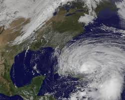
Hurricane Sandy's maximum sustained winds have increased to 85 mph. The storm's center sits more than 200 miles east of the North Carolina-Virginia coast. Hurricane force winds extend outward 175 miles, and tropical storm force winds extend 485 miles. Sandy is moving northward at 14-15 mph and is expected to turn toward the northwest today and toward the west-northwest tonight, when she is expected to make landfall along the southern New Jersey coast.

Strong winds and rain are expected throughout the Mid-Atlantic and Northeast. Storm surge could cause extensive flooding in ordinarily dry areas. Long Island Sound, Raritan Bay and New York Harbor could see water levels rise by six to eleven feet. Connecticut and Rhode Island sea coasts could see a storm surge of three to eight feet higher than normal. Two to three feet of heavy snow is expected to fall in the mountains of West Virginia, with a foot or more in higher elevation areas nearby.

In Vermont, the strongest winds are anticipated for the mountain slopes (see map), though the entire state could experience winds of 50 mph or more.


Update, Oct. 28, 2012, 6 p.m.
Vermont Governor Peter Shumlin has declared a state of emergency in advance of the arrival of Hurricane Sandy's winds and rain. He said he made the declaration in order that the state would have access to National Guard troops and federal emergency funds if needed.

The National Weather Service is warning that Sandy will bring life-threatening storm surge flooding to the Mid-Atlantic coast, including Long Island Sound and New York Harbor, coastal hurricane-force winds and heavy Appalachian snows. The service's 5 p.m. advisory indicates that Hurricane Sandy will be approaching the Mid-Atlantic coast by Monday night. It may be strengthened at that time through combination with a cold front moving in from the west.

Hurricane force winds extend outward up to 175 miles from the storm center. Tropical storm force winds extend 520 miles. Sandy is closely following the projected track for the storm. It is expected to make a left turn Monday night and make landfall somewhere on the New Jersey coast.

New York City may experience some of the worst storm conditions. City schools already have been closed for tomorrow. Dozens of schools are being used as evacuation centers. Some mandatory evacuations have been ordered for flood-prone areas of the city. Mass transit in the city is shutting down tonight until further notice.

It appears that Vermont will be spared the worst of the storm, but high winds could still cause damage and knock out electrical power for residents. Airlines across the Northeast have canceled flights. On Monday, Amtrak will halt service across the Eastern Seaboard, including Vermont service. The storm's effects will be felt most strongly Monday evening. However, showers related to Sandy's remnants are expected to linger until next weekend.


Update, Oct. 28, 2012, 12:45 p.m.
A National Weather Service High Wind Warning is in effect for all of Vermont from 2 p.m. Monday through 11 a.m. Tuesday. The strongest winds are expected Monday night from dusk until about midnight. Western mountain slopes will experience the highest gusts of 60-75 mph. Others will experience winds of 50 mph or more. Winds are expected to die down considerably during Tuesday. Residents are warned to plan ahead for possible power outages.

The National Weather Service has also issued a flood watch for portions of central and southern Vermont. Minor flooding of poor drainage areas is possible.

Numerous school districts in the State of Connecticut already have canceled school for Monday and Tuesday, anticipating flooding and damaging winds. Areas of Connecticut were repeatedly left without electrical power for weeks after two storms in late summer and fall last year.


Update, Oct. 28, 2012, 7 a.m.
Hurricane Sandy, now located more than 200 miles off the South Carolina coast, continues to move toward the northeast. She is expected to continue that course today and to turn abruptly to the northwest on Monday. Maximum sustained winds are now about 65-75 mph. Hurricane force winds extend outward as much as 100 miles and tropical storm winds as much as 500 miles. Winds will be felt in the mid-Atlantic states during the day and will become near hurricane force by Monday morning.

Current projections are focusing on landfall at the central New Jersey coast early Tuesday morning and a progression into central Pennsylvania. The storm, bringing dangerous winds, drenching rain and storm surge, is expected to weaken quickly after landfall, though storm effects will continue to be felt hundreds of miles away from its center. During Tuesday and into Wednesday, the remnants of Sandy are expected to turn back toward the northeast, causing continued rain and strong winds in New York and much of New England until it passes into eastern Canada by the end of the week.

A high wind watch is already in effect for all of Vermont. A flood watch is in effect through Wednesday morning for central and southern Vermont. Authorities do not expect much in the way of flooding from this storm, though some may occur in poor drainage areas. The state is expected to experience rain - occasionally heavy - and strong winds Monday into Tuesday. Winds will die down and the rest of the week's forecast calls for rain showers.


Update, Oct. 27, 2012
It appears that Vermont will be spared much of the wind and rain associated with Hurricane Sandy. However, high winds of 40 mph or more are expected for early next week and there will be considerable rainfall in some areas, particularly eastern facing mountain slopes. Power outages could accompany the high winds and some minor flooding is possible in poor drainage areas.

Sandy weakened just a bit overnight and was momentarily dropped down to tropical storm status. More recently, hurricane force winds were detected. The storm is growing considerably larger and is expected to grow further through combination with other weather systems in the region. The storm is tracking parallel to the southeastern U.S. coast but will turn dramatically left within two days, likely making landfall on the New Jersey coast Monday. A later left turn is still possible. That would cause Sandy to strike southern New England.

After landfall, Sandy may slow or halt as it combines with a large cold front from from the west. Any slowing in its movement will magnify the storm's effects on the region. Rain amounts of 3-6 inches are expected from coastal areas of Virginia to New York City, with 10+ inches possible in some areas. Heavy rains are expected as far inland as Pittsburgh and Buffalo. A foot or more of heavy wet snow is possible in the Appalachian mountain areas of West Virginia and Pennsylvania.


Update, Oct. 26, 2012
The computer models appear to be settling on a Sandy strike along the Northeast coast sometime late Monday. The New Jersey area seems to be the current focus. A merge with several other weather systems and the development of a Halloween "Frankenstorm" over the New York City region is feared.

Worst case seems to be a Sandy right-hook to New York City just as the storm stalls. That could deliver days of strong winds, intense rain and coastal flooding to the heavily populated region. Sandy is now a Category 1 hurricane with maximum sustained winds of 80 mph.


October 25, 2012
Hurricane Sandy, now a strong Category 2, is moving across Cuba at the moment. The storm has a well defined eye and includes maximum sustained winds of more than 100 mph. It is expected to track to the east of Florida into the Atlantic Ocean. Some forecast models show the storm doing an unusual counter-clockwise loop as it moves north and making landfall in the New York-New England area. The models are based on a trough of atmospheric pressure over the U.S., which could draw the hurricane inland in the Northeast late Monday or Tuesday.

Vermont's experience with Tropical Storm Irene illustrated the importance of communication through various levels of government and emergency services. Communication has been strengthened in the storm's aftermath and may get a test from Sandy.

Mark Bosma of Vermont Emergency Management recommends that state residents consider purchasing extra food, water and batteries - items that won't be wasted if the storm decides to remain out at sea. "We always encourage the public to be ready for anything," Bosma said.

29 September 2012

CT→VT: Our move, part 2


Some background
(Return to Part 1)

I spent my earliest years in the Bronx, New York. When I was about 11 and a half, we moved to Danbury, Connecticut. Moving from a fourth-floor apartment to a raised ranch on a half acre didn't cause much in the way of culture shock, as my grandparents for many years had a summer home nearby in New Fairfield. I was already somewhat acquainted with Connecticut and comfortable in the area. I appreciated many of the changes: waking up in the summer to the sound of birds singing, being able to ride my bike in relative safety on the streets, eating hickory nuts that had been dropped by a tree along our driveway, making "forts" out of branches in the small bit of woods that lined the backyard. Aside from one year, during which I lived in a tiny apartment just over the New York State line in Patterson, I spent the next thirty-seven of my forty-eight-plus years on Earth living in and mostly enjoying western Connecticut.

My wife Anna grew up in the Waterbury, Connecticut, area and went to college at the University of Connecticut. When we married in the autumn of 1991, we moved into a home - a pretty split-level ranch on a half acre on a dead end road - in the town of New Milford in southwestern Litchfield County. In terms of land area, New Milford is a very large town. But it was not very built up when we moved there.

It was not a wild frontier, by any means. There was plenty of shopping and a fair number of industrial and office buildings and a fine hospital. But there was also a great deal of open space. In our neighborhood, in the south of town just off Route 7, there were a number of unused and lightly wooded lots. Along commercially developed Route 7, there were vast stretches of woods and open fields. It wasn't entirely a country setting, but it was country enough for us.

Anna and I appreciate quiet and a degree of seclusion. We want our home to be a place where we can enjoy each other and our kids and our pets without intrusion. We like to see trees and fields and hills around us. And we generally dislike seeing other people's houselights. Our home was ideal for us. Large evergreen trees created walls along the back and one side of the property. Several trees and a large front yard shielded us from the road. One side neighbor was a bit close, but you could only see that house from garage windows that we kept curtained.

Even assuming a modest pace of development, we imagined we'd be comfortable in New Milford for a long time. Well, I guess it was a long time - more than twenty years.

Things change. And development doesn't always take a modest pace. The woods and fields along Route 7 gradually shrank and disappeared, replaced by large stores and restaurants and their parking lots. I recall years ago walking a number of times through a pretty field with large old trees which has since been flattened and asphalted over. We saw K-Mart come in. Big-Y took over a shopping center north of there. Then Walmart moved in to the south. K-Mart was replaced by Home Depot. Staples and T.J. Maxx opened a plaza and then developers began clearing and leveling an enormous stretch of open land across from Walmart.

By that time, we had fled the Route 7 corridor and scampered across town. We moved into a newer home in a very small subdivision with large, lightly wooded yards and many acres of thickly wooded sloping land across the street. We fought just a bit against encroaching civilization, bringing a horse and a bunny and six hens onto our new two-acre property with us. We composted manure, grew a few vegetables and ate a whole lot of eggs. Anna regularly rode her horse down dirt trails into the woods and over the streams across the street. Traffic hummed not far away, but we had an oasis of calm and quiet. For a while.

To be continued.

28 September 2012

CT→VT: Our move, part 1


'Why I went to the woods'
(well, not to "the woods," actually; it's more 
like farmland, though there are some woods nearby,
and a bit of swamp, too, but we don't live in that).

"I went to the woods because I wished to live deliberately, to front only the essential facts of life, and see if I could not learn what it had to teach, and not, when I came to die, discover that I had not lived. I did not wish to live what was not life, living is so dear; nor did I wish to practice resignation, unless it was quite necessary. I wanted to live deep and suck out all the marrow of life, to live so sturdily and Spartan-like as to put to rout all that was not life, to cut a broad swath and shave close..."
- Henry David Thoreau.

Umm... Yeah, I suppose some of that applies to our situation. For example, I DO always shave close! I sort of also sympathize with Thoreau's philosophical objection to living "what was not life" - the set of rules imposed on individual existence by outside forces. And my wife and I do sincerely share Thoreau's desire for a simpler, more deliberate existence..., as long as all the essential elements - you know, Internet, cellphone signal, good TV reception - remain readily available. (By the way, Thoreau only mentioned much later on that his family home was just a couple of miles away from his "sturdy and Spartan-like" existence in "the woods." What a wuss!)

I'm sorry to report that is the extent of my agreement with Thoreau. You see, I'm not much of a marrow-sucker. By that, I mean that I'm not the kind of person who seeks out all the raw and exciting natural experiences. I'm sure there are plenty of those experiences in Vermont - I just read about a guy who shot and killed a 500-pound bear in his backyard down in Pownal - but that's not what I'm looking for. Despite my surname, I don't hunt. I don't mountain-climb or hike or go boating or even ski. I tend to avoid anything that looks in any way interesting. Boring is just fine for me. And it may be fair to say that our move from Connecticut to Vermont in the summer of 2012 was, at least in part, a quest for ultimate boredom.

I'll get into explaining some of that in Part 2, which will be posted as soon as I think of what to write and have the time to actually write it. I imagine what I've written so far is enough for an introductory Part 1. So that's all you get for now.